![](/images/other/stat-length.png)
![Randonnée Marche Le Barroux - Le Barroux les deux abbaye, aqueduc occulus du barroux - Photo](https://media.geolcdn.com/t/1900/400/ec9af22f-dc3b-476c-aa5d-93ff2c13e438.jpg&format=pjpeg&maxdim=2)
Le Barroux les deux abbaye, aqueduc occulus du barroux
FLORENSAC
Utilisateur
![Longueur](/images/other/stat-length.png)
Longueur
13,4 km
![Altitude max](https://static1.geolcdn.com/siteimages/upload/files/1508320355ic_sort_altitude_max_24dp.png)
Altitude max
395 m
![Dénivelé positif](https://static1.geolcdn.com/siteimages/upload/files/1508320355ic_sort_den_pos_24dp.png)
Dénivelé positif
365 m
![Km-Effort](/images/other/stat-length.png)
Km-Effort
18,3 km
![Altitude min](https://static1.geolcdn.com/siteimages/upload/files/1508320355ic_sort_altitude_min_24dp.png)
Altitude min
258 m
![Dénivelé négatif](https://static1.geolcdn.com/siteimages/upload/files/1508320355ic_sort_den_neg_24dp.png)
Dénivelé négatif
366 m
![Boucle](https://static1.geolcdn.com/siteimages/upload/files/16400158638029165_repeat_loop_refresh_sync_direction_icon.png)
Boucle
Oui
Date de création :
2025-02-13 09:01:23.302
Dernière modification :
2025-02-13 14:33:32.133
![Marche](https://static1.geolcdn.com/sitytour/trail-icons/101.png)
5h31
Difficulté : Difficile
![Scannez ce code QR pour ouvrir la randonnée dans l'application SityTrail](https://capi.geolives.com/qq0zvz2zws4bq2lad0pu/sitytour/trails/4352432/qr.png?size=200)
Application GPS de randonnée GRATUITE
À propos
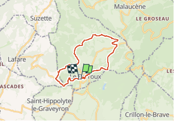
Randonnée Marche de 13,4 km à découvrir à Provence-Alpes-Côte d'Azur, Vaucluse, Le Barroux. Cette randonnée est proposée par FLORENSAC.
Description
belle boucle avec un peu de denivellé
on a mange a l abbaye de l annociation
tables et bancs a disposition
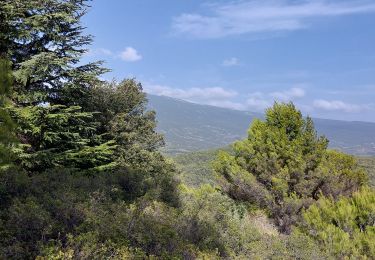
l occulus est un peu cache par la vegetation surtout l eté 😉
Localisation
Pays :
France
Région :
Provence-Alpes-Côte d'Azur
Département/Province :
Vaucluse
Commune :
Le Barroux
Localité :
Unknown
Départ:(Dec)
Départ:(UTM)
667768 ; 4889094 (31T) N.
Commentaires
Randonnées à proximité
![Randonnée Marche Lafare - Le tour du Grand Montmirail - Lafare - Photo](https://media.geolcdn.com/t/375/260/ext.jpg?maxdim=2&url=https%3A%2F%2Fservices.sitytrail.com%2FGeolivesWS%2FDownloadMedia.ashx%3FTrailID%3D107159%26Media%3D12002_4.jpg)
![Marche Marche](https://static1.geolcdn.com/sitytour/trail-icons/101.png)
Le tour du Grand Montmirail - Lafare
Marche
Moyen
(3)
Lafare,
Provence-Alpes-Côte d'Azur,
Vaucluse,
France
![](/images/other/stat-length.png)
9,1 km | 13,9 km-effort
2h 30min
![](https://static1.geolcdn.com/siteimages/upload/files/16400158638029165_repeat_loop_refresh_sync_direction_icon.png)
Oui
![Randonnée Marche Saint-Hippolyte-le-Graveyron - Le graveron petit circuit - Photo](https://media.geolcdn.com/t/375/260/e8a95e9c-8711-4425-b0b6-166adebefe20.jpg&format=jpg&maxdim=2)
![Marche Marche](https://static1.geolcdn.com/sitytour/trail-icons/101.png)
Le graveron petit circuit
Marche
Facile
(1)
Saint-Hippolyte-le-Graveyron,
Provence-Alpes-Côte d'Azur,
Vaucluse,
France
![](/images/other/stat-length.png)
5,7 km | 8,8 km-effort
2h 5min
![](https://static1.geolcdn.com/siteimages/upload/files/16400158638029165_repeat_loop_refresh_sync_direction_icon.png)
Oui
![Randonnée Marche Lafare - Une approche des Dentelles de Montmirail - Photo](https://media.geolcdn.com/t/375/260/ext.jpg?maxdim=2&url=https%3A%2F%2Fservices.sitytrail.com%2FGeolivesWS%2FDownloadMedia.ashx%3FTrailID%3D191525%26Media%3D15129_1.jpg)
![Marche Marche](https://static1.geolcdn.com/sitytour/trail-icons/101.png)
Une approche des Dentelles de Montmirail
Marche
Moyen
(2)
Lafare,
Provence-Alpes-Côte d'Azur,
Vaucluse,
France
![](/images/other/stat-length.png)
6,6 km | 11,4 km-effort
3h 0min
![](https://static1.geolcdn.com/siteimages/upload/files/16400158638029165_repeat_loop_refresh_sync_direction_icon.png)
Oui
![Randonnée Marche Crillon-le-Brave - Torrent Pied Blanc / Rocher de la Madeleine - Photo](https://media.geolcdn.com/t/375/260/3e6e01ec-58ac-4090-bfea-a9164d2e0785.jpg&format=jpg&maxdim=2)
![Marche Marche](https://static1.geolcdn.com/sitytour/trail-icons/101.png)
Torrent Pied Blanc / Rocher de la Madeleine
Marche
Moyen
Crillon-le-Brave,
Provence-Alpes-Côte d'Azur,
Vaucluse,
France
![](/images/other/stat-length.png)
8,2 km | 11,5 km-effort
2h 18min
![](https://static1.geolcdn.com/siteimages/upload/files/16400158638029165_repeat_loop_refresh_sync_direction_icon.png)
Oui
![Randonnée Marche Le Barroux - Les Crêtes du Graveyron par l'écluse de la Falque - Photo](https://media.geolcdn.com/t/375/260/d8a64516-5e96-4aec-9024-3e89e87cb4a5.jpg&format=jpg&maxdim=2)
![Marche Marche](https://static1.geolcdn.com/sitytour/trail-icons/101.png)
Les Crêtes du Graveyron par l'écluse de la Falque
Marche
Difficile
Le Barroux,
Provence-Alpes-Côte d'Azur,
Vaucluse,
France
![](/images/other/stat-length.png)
9 km | 13,4 km-effort
2h 57min
![](https://static1.geolcdn.com/siteimages/upload/files/16400158638029165_repeat_loop_refresh_sync_direction_icon.png)
Oui
![Randonnée Marche Caromb - Les 3 Termes 449 le Groseau - Photo](https://media.geolcdn.com/t/375/260/10d32099-293b-4d37-bbde-b3ecd67a6725.jpg&format=jpg&maxdim=2)
![Marche Marche](https://static1.geolcdn.com/sitytour/trail-icons/101.png)
Les 3 Termes 449 le Groseau
Marche
Moyen
Caromb,
Provence-Alpes-Côte d'Azur,
Vaucluse,
France
![](/images/other/stat-length.png)
11,1 km | 16,9 km-effort
2h 56min
![](https://static1.geolcdn.com/siteimages/upload/files/16400158638029165_repeat_loop_refresh_sync_direction_icon.png)
Oui
![Randonnée Marche La Roque-Alric - Les 4 sommets de la Roque Alric - Photo](https://media.geolcdn.com/t/375/260/e93bea38-2e31-43c6-94e2-77f41c5e7792.jpg&format=jpg&maxdim=2)
![Marche Marche](https://static1.geolcdn.com/sitytour/trail-icons/101.png)
Les 4 sommets de la Roque Alric
Marche
Moyen
La Roque-Alric,
Provence-Alpes-Côte d'Azur,
Vaucluse,
France
![](/images/other/stat-length.png)
10,9 km | 18 km-effort
3h 32min
![](https://static1.geolcdn.com/siteimages/upload/files/16400158638029165_repeat_loop_refresh_sync_direction_icon.png)
Oui
![Randonnée Marche La Roque-Alric - Rochers des Évêques - Photo](https://media.geolcdn.com/t/375/260/07ede647-be75-4726-a51b-6e74ff5b2210.jpg&format=jpg&maxdim=2)
![Marche Marche](https://static1.geolcdn.com/sitytour/trail-icons/101.png)
Rochers des Évêques
Marche
Moyen
La Roque-Alric,
Provence-Alpes-Côte d'Azur,
Vaucluse,
France
![](/images/other/stat-length.png)
6,7 km | 11 km-effort
2h 26min
![](https://static1.geolcdn.com/siteimages/upload/files/16400158638029165_repeat_loop_refresh_sync_direction_icon.png)
Oui
![Randonnée Marche Le Barroux - Lac du Barroux - Photo](https://media.geolcdn.com/t/375/260/ext.jpg?maxdim=2&url=https%3A%2F%2Fservices.sitytrail.com%2FGeolivesWS%2FDownloadMedia.ashx%3FTrailID%3D254117%26Media%3Dfix__20140304143604.jpg)
![Marche Marche](https://static1.geolcdn.com/sitytour/trail-icons/101.png)
Lac du Barroux
Marche
Très facile
(2)
Le Barroux,
Provence-Alpes-Côte d'Azur,
Vaucluse,
France
![](/images/other/stat-length.png)
5,8 km | 8 km-effort
1h 42min
![](https://static1.geolcdn.com/siteimages/upload/files/16400158638029165_repeat_loop_refresh_sync_direction_icon.png)
Oui